
Caglar Koylu might know 40 million of your relatives.
Koylu, geographer and associate professor in the School of Earth, Environment, and Sustainability and researcher affiliate in the Center for Social Science Innovation (CSSI), has constructed a titantic-like family tree – in fact, the largest ever – linking millions of Americans all the way back to when kingdoms reigned.
This task was no small undertaking. Koylu spent nearly a decade cleaning and connecting publicly available, online genealogical trees, rooted from 1630 to 1930. Once the family web was woven, Koylu began to trace the changes in the birthplace of children in each family. By doing so, Koylu could map how the family moved from location to location, particularly across the rugged American frontier.
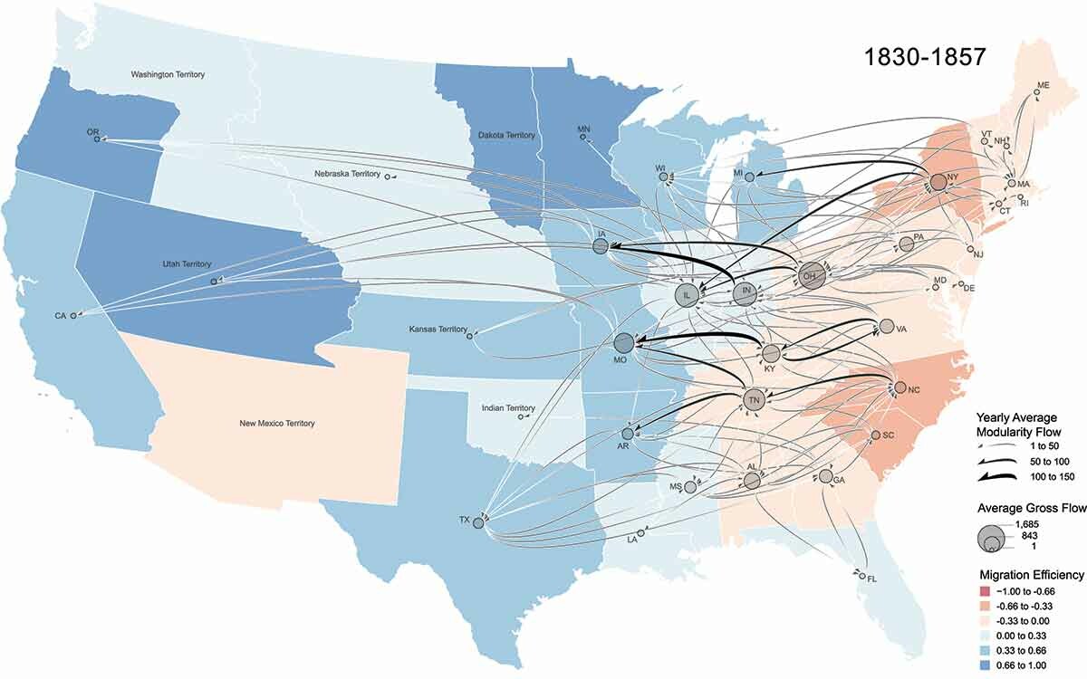
One of Koylu’s first-of-its-kind maps. While Koylu can create similar maps at any time slice of his three-century family tree, this map captures one period of heavy family movement: Westward Expansion. The lines or “yearly average modularity flow” represent the number of families moving. The thicker and darker the lines, the more families that trekked across that path. The circles or “average gross flow” represent the flux of migrant families; large circles mean many people were moving in or out of the state or territory. Finally, the colors symbolize migration rate or “migration efficiency.” States and territories colored orange were losing families, while blue-hued areas were gaining individuals. Altogether, Koylu’s map shows clear movement across the frontier.
“In a map like this, you portray three unique ways of looking at the data, making it the first ever map to show this much detail about migration in the U.S. during the 19th century,” explains Koylu.
Koylu, who grew up in Turkey, had long been spellbound by maps and mapping, majoring in city and regional planning at the Middle East Technical University. After later earning a master’s in geodetic and geographic information technologies at the same school, he spent a few years developing a 3D map of flying conditions in the real world for helicopter pilot training, using satellite imagery, 3D modeling, and geographic information systems within an immersive simulation platform.
Upon arriving in the United States, Koylu obtained a PhD in geography from the University of South Carolina. Since joining the University of Iowa in 2015, Koylu has been studying geographical and social phenomena across time and space, such as historical human movements.
The project, supported by a grant won with the assistance of CSSI’s grant development team, included an experiment that matched individuals in the family tree to their corresponding records in the 1880 U.S. Census. Those matches represented about 3% of everyone recorded in the Census.
While Koylu deems this discovery “amazing” due to the crowdsourced nature of his family tree, he is careful to point out that online family trees tend to include a higher representation of males, individuals in agriculture, and white individuals born in the U.S.
Presently, Koylu is focusing on groups with less historical documentation, particularly Black and Indigenous Americans. His efforts have resulted in the development of an online educational tool called “Roots & Migrants.”
Currently being workshopped by Iowa City-area high schoolers, this resource will allow students to interact with maps that depict historical events faced by marginalized populations (such as the Indian Removal Act) and the Westward Expansion maps derived from Koylu’s family tree.
Although Koylu’s research chiefly characterizes the past, he also sees its application in the present.
“All these questions about migration can explain what makes our society the way we are as a melting pot. This could explain a lot of the societal problems we have right now,” Koylu divulges.
“The solution relies in understanding who we are. We have always been migrants, and we will continue to be migrants.”
Endless methodological quests
There are no pre-made tools for Koylu’s research, so he handcrafts the statistical and visual techniques and algorithms necessary for the research inquiry at hand. And Koylu’s inquiries are multifold, spanning various geographical and social processes.
For instance, he recently collaborated with researchers in the university’s College of Public Health to develop a cancer mapping tool. And a few years ago, he used cellphone data to trace people’s movements during the COVID-19 lockdown, discovering that socially vulnerable groups became more mobile.
He is also investigating whether certain demographics are disproportionately burdened by groundwater pollution, a topic he addressed in his CSSI methodological workshop last spring.
Finally, Koylu has leveraged social media data to understand the prevalence of neighborhood crime, a topic born from a collaboration with James Wo, associate professor in the Department of Criminology and Sociology, whom he met through CSSI’s networking opportunities.
For Koylu, dipping his toes in various research ponds is fueled by his innate inquisitiveness.
“My main motivation has always been curiosity and being able to add something new to our knowledge, whether it’s about migration, cancer, or any other geographic process,” Koylu reflects.
To learn more about CSSI’s researcher affiliate program, please visit our website.
For emails about CSSI news and opportunities in support of social science research across the University of Iowa campus, within our communities, and beyond, subscribe here.